|
The following are some examples of our recent research.
1. Estuarine, Coastal, Nearshore Processes and Biophysical ModelingCoastal water quality is important not only from the point of human health but also because poor water quality negatively impacts local economies. The development and application of predictive models is important to protect the public and to manage coastal resources effectively. We use field experiments and numerical models to understand the relative importance of different processes in the nearshore regions of large lakes such as Lake Michigan and Lake Huron and to improve predictions using mathematical models. We are refining the descriptions of physical and biological processes in our models (e.g., sediment resuspension, nearshore transport in the presence of currents and waves) and using new data (e.g., data from Lagrangian drifters and remote sensing) to improve / constrain models. The ultimate goal of this research is to make predictive modeling an attractive alternative to more traditional approaches based on observation for managing coastal resources.
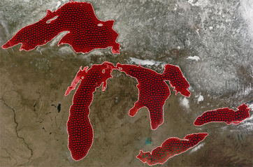
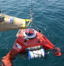
(Left) Computational grids for the Great Lakes and (Right) A 600 kHz Sentinel ADCP being deployed in southern Lake Michigan in summer 2008
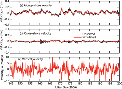
(Top) Observed and simulated horizontal currents (vertically-averaged) in Lake Michigan (Indiana beaches, 2006)
Sample Publications
2. Integrated Hydrologic Modeling
We use distributed hydrologic models (e.g., PAWS and other similar models) to understand watershed processes and to quantify fluxes of water, nutrients (C,N,P), sediment and bacteria at downstream receiving water bodies such as lakes and oceans to help manage resources and to protect the public from exposure to contaminated waterways (by making timely predictions; see the section on nearshore processes above). Refinement of process descriptions, model testing using new types of data (e.g., satellite products, data from sensor networks) and data assimilation continue to be areas of interest in our group.
Key processes included in the PAWS model (Niu et al., Water Resour. Res., 2014)
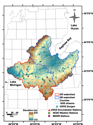
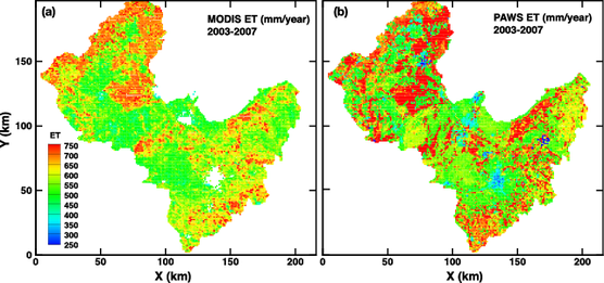
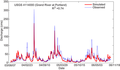
(Left panel): Map showing the Grand River and Saginaw Bay watersheds - the two largest watersheds (by drainage area) in the state of Michigan. The watersheds drain to lakes Michigan and Huron (Right, top panel): Multiple-year-average evapotranspiration (ET) in the Saginaw Bay watershed: Comparison between MODIS data and PAWS model results (Niu et al., 2014) (Right, bottom Panel): Comparison of observed (USGS) and simulated (PAWS) streamflows in the Grand River watershed
Sample Publications
3. River Research and Groundwater - Surface Water InteractionsIntegrated watershed modeling offers one example of GW-SW interactions at the river basin scale. Several small-scale processes (e.g., interactions with river bed sediments / hyporheic exchange and surface storage zones) control the dynamics of solute transport at the river reach scale. Understanding these small-scale processes is important to accurately describe the transport of conservative (e.g., salt) and reactive (e.g., nutrients) solutes at the river reach scale and to address many questions involving biogeochemical cycles. Research in our group aims to improve our ability to describe solute transport in rivers, streams and river networks using improved mathematical models and field observations.
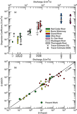
(Left) Typical ADCP velocity transect data from rivers in the US Midwest used for estimating longitudinal dispersion coefficients (Right) Comparison of longitudinal dispersion coefficients based on two methods: (a) the traditional tracer-based approach and (b) the ADCP method based on the theory of shear-flow dispersion
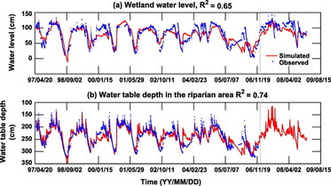
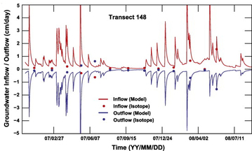
Wetland - aquifer interactions at a site in Norman, Oklahoma quantified using process-based modeling (left) and isotopes (right panel) of oxygen and hydrogen ( 16O, 18O, 1H, 2H).
Sample Publications
|